 PDF(19475 KB)

Characteristics and controlling factors of large carbonate oil and gas fields in Africa
XIAO Kunye, ZHAO Ning, CHEN Yajing, LIN Zimo, SUO Xiaofei, MA Xueying, ZHOU Hongpu, OU Yafei
Marine Origin Petroleum Geology ›› 2025, Vol. 30 ›› Issue (5) : 413-424.
PDF(19475 KB)
PDF(19475 KB)
Characteristics and controlling factors of large carbonate oil and gas fields in Africa
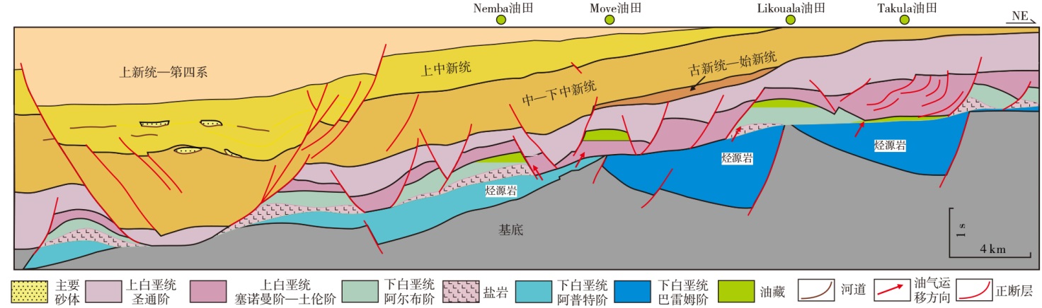
Large carbonate hydrocarbon fields have long been a global research focus. Statistical analysis of IHS data reveals that Africa's giant carbonate oil and gas fields are mainly distributed in five basins: the Sirte, Pelagian, and Eratosthenes basins in North Africa, and the Lower Congo and Kwanza basins in West Africa. Among them, Sirte Basin accounts for 48.2% of Africa's total carbonate oil and gas reserves, making it the most prolific. Through detailed analysis of 19 large carbonate oil and gas fields, the conclusions are drawn as following: (1) The passive-margin marine transgressions associated with the Late Cretaceous-Eocene opening of the Neo-Tethys Ocean and South Atlantic are prerequisites for large-scale hydrocarbon accumulation in carbonate rocks, with the main reservoirs developed in the Cretaceous, Paleocene, and Eocene strata. (2) Unlike deep-water carbonate rocks, the shallow marine sedimentary environment and low latitude warm and humid climate after the breakup of Gondwana continent control the scale distribution of reservoirs and source rocks, forming various types of reservoirs mainly composed of bioclastic limestone, with dolomite, foraminifera limestone, oolitic limestone, and reef limestone as secondary reservoirs, and high-quality source rocks mainly composed of shallow marine shale. (3) During the base-level rise period (lowstand to transgressive system tracts), multiple sets of marine shale (source)-carbonate rock (reservoir)-shale (cap) combinations tend to develop. Subsequently, through sedimentary burial and tectonic processes, structural traps and stratigraphic-lithologic traps are primarily formed, leading to hydrocarbon accumulation. (4) The widely developed limestones, grainstones, and dolomites, along with diagenetic processes, governs the effective reservoirs and physical properties of large carbonate oil and gas fields. Large oil reservoirs are characterized by moderate to high porosity and moderate to low permeability, whereas large gas reservoirs typically exhibit moderate to low porosity and moderate to high permeability. From the distribution of recoverable oil and gas reserves in African carbonate rocks, there is still a huge exploration space, and the mature theoretical techniques in the genesis and characterization of carbonate reservoirs in China are worthy of further referencing.
carbonate rocks / reservoir characteristics / large oil and gas fields / characteristics of hydrocarbon accumulation / main controlling factors / Africa
| [1] |
|
| [2] |
|
| [3] |
|
| [4] |
|
| [5] |
|
| [6] |
|
| [7] |
|
| [8] |
|
| [9] |
|
| [10] |
|
| [11] |
|
| [12] |
|
| [13] |
|
| [14] |
洛怡, 李江海, 杨梦莲. 南大西洋西非岸盆地群构造、沉积演化对比[J]. 中国地质, 2021, 48(1): 120-128.
|
| [15] |
郑多明, 李志华, 赵宽志, 等. 塔里木油田奥陶系碳酸盐岩缝洞储层的定量地震描述[J]. 中国石油勘探, 2011, 16(5): 57-62, 78.
|
| [16] |
王大兴, 曾令帮, 张盟勃, 等. 鄂尔多斯盆地台缘带下古生界碳酸盐岩储层预测与综合评价[J]. 中国石油勘探, 2011, 16(5): 89-94, 110.
|
| [17] |
黄臣军, 刘格云, 焦存礼, 等. 塔西南中—下奥陶统裂缝-流体时序与储层演化[J]. 天然气地球科学, 2025, 36(6): 1012-1027.
碳酸盐岩储层形成与演化机制是油气勘探亟需解决的关键问题之一。以塔里木盆地西南部玉北地区中—下奥陶统为例,利用钻井岩心、岩石薄片、成像测井、常规测井及地球化学数据等,从裂缝—流体时序研究入手,厘定碳酸盐岩储层成岩演化过程,明确储层发育控制因素。根据含不同类型充填物岩心裂缝的切割关系,厘定玉北地区中—下奥陶统先后发生了富镁流体、富硅流体、古油气、富钙流体和富泥流体的活动。通过岩心和薄片白云石充填缝对比分析,提出富镁流体活动发生在加里东中期Ⅰ幕初期的微观裂缝发育阶段,并导致过度白云石化。元素和同位素分析表明,导致过度白云石化的富镁流体为热液成因,可能与寒武系膏盐岩层高温富镁卤水因重力压实作用而向上渗透扩散有关。玉北地区蓬莱坝组—鹰山组下段溶蚀孔洞产状特征表明,其形成早于白云石化,与准同生期三、四级沉积旋回海平面下降暴露溶蚀相关。将玉北地区中—下奥陶统储层演化划分为蓬莱坝组—鹰山组下段准同生溶蚀、加里东中期Ⅰ幕与海西晚期热液白云石化—构造裂缝共同作用、海西晚期之后储层保持3个阶段。
The formation and evolution mechanism of carbonate reservoir is one of the key issues to be solved in oil and gas exploration. Taking the middle-lower Ordovician in the Yubei area, the Southwest Tarim Basin as an example, we utilized drilling cores, thin sections, FMI logs, conventional logs and geochemical data to obtain the diagenetic evolution process of carbonate reservoirs and reveal the controlling factors of reservoir development, based on the study of fracture-fluid chronology. According to the cutting relationship of core fractures containing different types of fillings, it is determined that the activities of Mg-rich fluid, silica-rich fluid, paleo oil and gas, calcium-rich fluids and mud-rich fluids occurred successively in the Middle-Lower Ordovician in Yubei area. Through the comparative analysis of core and thin-section dolomite-filling fractures, it is proposed that the Mg-rich fluid activity has occurred in the stage of microscopic-fracture development in the early Episode I of the middle Caledonian, which has led to excessive dolomitization. The analysis of elements and isotopes shows that the Mg-rich fluid leading to the excessive dolomitization is of hydrothermal origin, which may be related to the upward permeation and diffusion of high temperature magnesium-rich brine from the Cambrian gypsum strata due to gravity compaction. The occurrence characteristics of the dissolution cavities in the Penglaiba Formation-Yingshan Formation (lower member) in the Yubei area indicate that its formation is earlier than that of dolomitization. The dissolution resulted from subaerial exposure during sea-level fall in the third and fourth sedimentary cycles of the quasi-syngenetic period. The evolution of the Middle-Lower Ordovician reservoir in the Yubei area could be divided into three stages: the quasi-syngenetic dissolution of Penglaiba Formation-Yingshan Formation (lower member), the joint interaction of hydrothermal dolomitization and structural fractures in the middle Caledonian Episode I and the late Hercynian, as well as the reservoir maintenance after the late Hercynian. |
| [18] |
王琦, 张银涛, 张晶, 等. 缝洞型碳酸盐岩储层地质建模研究进展[J]. 海相油气地质. 2024, 29(1): 99-112.
The fracture-cavity carbonate reservoirs is characterized by complex spatial distribution and high heterogeneity.The establishment of an accurate and reliable three-dimensional geological model is fundamental and essential for the efficient development of such reservoirs.This paper presents a comprehensive overview of the developing stages in the technology and methods employed for modeling fracture-cavity carbonate reservoirs.The evolution of fracture-cavity reservoir modeling can be delineated into three distinct phases:In the first phase,reservoir modeling techniques introduce concepts like"zone division"and"karstic control"as methods for modeling reservoir bodies,with a primary reliance on variogram-based statistical algorithms.In the second phase,it is emphasized of the modeling of internal cave structures,which involves categorizing cave types and summarizing different combinations of cave types.These endeavors are underpinned by the application of geological constraints to construct various karstic control models,with a predominant focus on target-based and multi-point geological statistics as modeling algorithms.In the third phase,the researcher further delve into the causal factors governing the formation of reservoir bodies,specifically focusing on factors such as underground rivers.For these unique causal factor-driven cave reservoirs,field outcrop and cave data were employed to construct training images.Mathematical integration of prior geological causative models and posterior seismic responses result in the development of comprehensive constraint probability bodies.The models generated in this phase exhibite finer detail and have the capacity to represent internal structural elements within underground river reservoirs.This paper concludes by offering a forward-looking perspective on the technological advancements in geological modeling of fracture-cavity carbonate reservoirs.It highlights the imperative need for further research in fracture-controlled karst reservoir modeling methods and underscores that the future trajectory lies in artificial intelligence geological modeling methods based on deep learning.
|
| [19] |
谢鹏飞, 侯加根, 汪彦, 等. 碳酸盐岩缝洞型储层多元信息融合建模方法在塔河油田十二区奥陶系油藏的应用[J]. 中国石油大学学报(自然科学版), 2023, 47(3): 1-14.
|
| [20] |
陈叔阳, 何云峰, 王立鑫, 等. 塔里木盆地顺北1号断裂带奥陶系碳酸盐岩储层结构表征及三维地质建模[J]. 岩性油气藏, 2024, 36(2): 124-135.
综合利用地震、测井、岩心以及动态生产资料,对塔里木盆地顺北1号断裂带断控型碳酸盐岩储集体的内部结构进行了层级划分;基于层级划分,通过地震资料属性提取与转换、深度学习、基于目标示性点过程模拟以及离散裂缝网络模拟(DFN)等方法建立了三维地质模型,并以模型进行油气储量和油藏数值模拟,将拟合结果与实际生产数据进行对比。研究结果表明:①顺北1号断裂带奥陶系断控型储层按层级由大到小分为走滑断裂影响带、断控体、类洞穴、类洞穴内簇充填和裂缝带共5个层级。②走滑断裂影响带受应力差异影响具有分段性,可细分为挤压段、拉分段和平移段;断控体在拉分段发育断裂交会型、单支走滑型,在平移段发育双断裂交错型和两断裂交会型,在挤压段发育双断裂扭曲型和双断裂交会型,共有6种平面组合样式;类洞穴在地震剖面上呈串珠状反射特征;类洞穴内部分为栅体与栅间(基岩),其中栅体又可进一步分为簇(角砾带)、簇间(裂缝带),整体表现为栅状结构,簇的物性更好;裂缝带为类洞穴的主要储集空间,在簇内部比簇间更发育,在一间房组比鹰山组更发育,一间房组和鹰山组均以发育高角度裂缝为主,在两者连接处则以发育水平缝为主。③地质模型预测的油气储量与地质分析储量误差为1.75%,模型模拟的生产井地层压力及累产液结果与生产动态吻合度较高,拟合误差小于10%。
Based on the seismic,logging,core and dynamic data,the internal architecture of fault-controlled carbonate reservoirs in Shunbei No. 1 fault zone of Tarim Basin was divided. Based on the hierarchical division, a 3D geological model was established through seismic data attribute extraction and conversion,deep learning, target-based schematic point process simulation,and discrete fracture network simulation(DFN). Numerical simulation of oil and gas reserves and reservoirs was carried out with the model,and the fitting results were compared with the actual production data. The results show that:(1)The Ordovician fault-controlled reservoirs in the study area were categorized into five levels,from large to small,including strike-slip fault-influenced zones, fault-controlled bodies,cave-like,intra-cave-like cluster-filling and fracture zones.(2)The strike-slip faultinfluenced zones has segmentation due to stress differences,which can be subdivided into extrusion section, pullout section and translation section. The fault-control bodies develop six kinds of planar combination styles, including fault intersection type and single-branch slip type in the pullout section,double-fault staggered type and double-fault intersection type in the translation section,and double-fault twisted type and double-fault intersection type in the extrusion section. The cave-like is characterized by bead-like reflections on the seismic section. The intra-cave-like is divided into fenestration and inter-fenestration(bedrock),and the fenestration can be further divided into clusters(breccia zones)and inter-clusters(fracture zones),and the whole is characterized by fenestration structure,with better physical properties of the clusters. The fracture zones are the main reservoir space for cave-like structures,which are more developed within clusters than between clusters,and more developed in Yijianfang Formation than in Yingshan Formation. High-angle fractures are mainly developed in Yijianfang Formation and Yingshan Formation,while horizontal fractures are mainly developed at the joints between the two.(3)The error between the oil and gas reserves predicted by the geological model and the geological analysis reserves is 1.75%. The simulated production well formation pressure and cumulative liquid production results of the model are highly consistent with production performance,with a fitting error of less than 10%.
|
| [21] |
张宁宁, 何登发, 孙衍鹏, 等. 全球碳酸盐岩大油气田分布特征及其控制因素[J]. 中国石油勘探, 2014, 19(6): 54-65.
|
| [22] |
|
| [23] |
|
| [24] |
|
| [25] |
张静, 张宝民, 单秀琴. 古气候与古海洋对碳酸盐岩储集层发育的控制[J]. 石油勘探与开发, 2014, 41(1): 121-128.
以中国塔里木、四川及鄂尔多斯盆地碳酸盐岩重点层系为例,探讨古气候背景与古海洋环境联合控制海相碳酸盐岩储集层发育的机制。对海相碳酸盐岩沉积和储集层形成而言,古气候总体上有干热/干燥与湿热/湿润之分;显生宙海水的地球化学成分曾发生明显的周期性变化,方解石海与文石海交替出现。塔里木、四川及鄂尔多斯等盆地的油气勘探实践表明,海相碳酸盐岩规模储集层的孔隙类型与发育特征明显受控于其沉积时的古气候背景与古海洋环境。干热/干燥古气候背景下的文石海环境最有利于形成孔隙-孔洞型白云岩储集层;干热/干燥古气候背景下的方解石海环境可形成以发育蒸发盐铸模孔为主的孔隙型白云岩储集层。湿热/湿润古气候背景下的方解石海和文石海沉积则主要形成大型溶洞型储集层。古气候背景与古海洋环境联合控制了碳酸盐岩的沉积并深刻影响了其成岩作用,最终决定了规模储集层的孔隙特征和储集层类型。图5参33
The controlling effects of paleo-climate and paleo-ocean on the formation of marine carbonate reservoirs were studied taking key carbonate strata in the Tarim, Sichuan and Ordos Basins as examples. Dry heat/aridity and moist heat/moisture are the two distinctive types of paleo-climate background as far as carbonate sedimentation and reservoir formation are concerned. The geochemistry of the Phanerozoic ocean experienced cyclic variation, with calcite sea and aragonite sea occurring alternately. Carbonate exploration practice in the Tarim, Sichuan and Ordos Basins shows that the features of carbonate reservoir are evidently controlled by paleo-climate and paleo-ocean environment. The aragonite sea under dry heat/arid climate is most favorable for the formation of porous dolomite reservoirs. The calcite sea under dry heat/arid climate is favorable for the formation of porous dolomite reservoirs with evaporite moldic pores. The calcite sea and aragonite sea under moist heat/moist climate may only lead to the formation of cavernous carbonate reservoir. Paleo-climate and paleo-ocean environment exert great influence on carbonate sedimentation and its diagenesis, and ultimately determine the porosity features and types of carbonate reservoirs.
|
| [26] |
|

/
| 〈 |
|
〉 |


