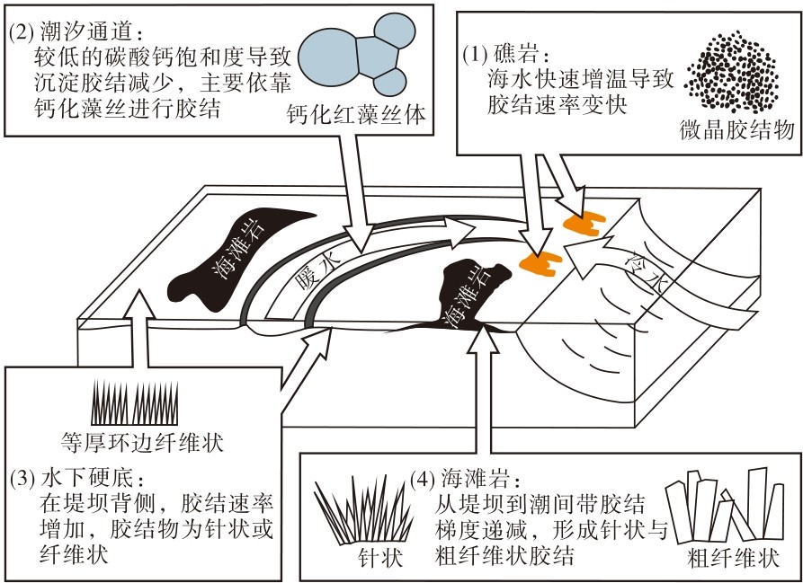
Early marine carbonate cements are an important component of marine carbonate depositional systems. They record key information on paleo-seawater chemistry and early diagenetic processes and play a significant role in the formation and evolution of carbonate reservoirs. Considering the limited research conducted in China and the great resource potential of marine carbonate reservoirs, this study systematically reviews and synthesizes previous studies on early marine carbonate cements worldwide. Their spatial and temporal distribution, morphological characteristics, mineral compositions, and major controlling factors are summarized. Previous studies indicate that early marine carbonate cements are widely developed in both ancient and modern carbonate depositional systems. Their primary mineral compositions are mainly aragonite and high-Mg calcite, and their common morphologies include acicular, fibrous, columnar, granular and others. The mineralogical and morphological evolution of these cements is mainly controlled by multiple factors, including seawater Mg/Ca ratio, CO₃²⁻, phosphate ions, SO₄²⁻, organic matter, temperature, salinity, sediment substrate, and crystal habits. Early marine cementation can significantly modify the pore structure of primary sediments and enhance the stability of the rock framework, thereby exerting an important influence on pore preservation and subsequent diagenetic evolution of carbonate reservoirs. A comprehensive understanding of the formation characteristics and controlling factors of early marine carbonate cements is crucial for revealing carbonate sedimentation-diagenesis processes and reservoir formation mechanisms, and it provides important theoretical guidance for hydrocarbon exploration in carbonate reservoirs.
To address the issues of strong heterogeneity in the 4th member of the Dengying Formation reservoir in the Sichuan Basin and insufficient constraints for reservoir prediction using subsurface data, a well-exposed (algae) mound-shoal complexes profile of the 4th member of the Dengying Formation in Ningqiang area, northern margin of the Sichuan Basin is selected as a field prototype model. Based on detailed field surveying, sampling, and rock thin section analysis, this study establishes a dolomite reservoir model and defines the spatial relationship between reservoir parameters and lithofacies architecture. The following insights are obtained: (1) The 4th member of the Dengying Formation in Ningqiang area can be divided into lower, middle, and upper sub-members, forming a shallowing-upward cycle from middle ramp to weakly rimmed platform margin to strongly rimmed platform margin. The main rock types are microbial dolomite and crystalline dolomite, with microbial dolomite being the dominant type, including algal peloidal dolomite, algal stromatolite dolomite, algal laminated dolomite, algal framework dolomite, and algal thrombolite dolomite. The upper sub-member develops typical platform-margin (algae) mound-shoal complexes, in which algal framework dolomite, algal stromatolite dolomite, and algal thrombolite dolomite have porosity > 4.5%; algal peloidal dolomite and fine-crystalline dolomite have porosity between 2.5% and 3.5%. Toward the interior of the platform, algal laminated dolomite, very fine-muddy crystalline dolomite have porosity < 2.5%. (2) The reservoir spaces in algal framework dolomite and algal thrombolite dolomite are characterized by large pores and throats; those in algal stromatolite dolomite, algal peloidal dolomite and fine-crystalline dolomite are characterized by medium-sized pores and throats; and those in algal laminated dolomite, very fine-muddy crystalline dolomite are characterized by small pores and throats, exhibiting a dual pore-throat structure. (3) The stacking pattern of the lithofacies is clear: algal peloidal dolomite and fine-crystalline dolomite represent clastic shoal deposits in the mound base and inter-mound areas; algal stromatolite dolomite represents deposits during the colonization stage of microbial mounds above the mound base; algal framework dolomite represents mound core construction; and algal thrombolite dolomite represents mound-flank deposits, exhibiting a "small mound, large shoal" pattern. These results indicate that the platform-margin mound-shoal complex in the upper sub-member of the 4th member of the Dengying Formation in northern Sichuan Basin is extensively developed, representing a favorable zone for high-quality reservoir development.

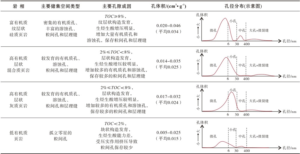
Exploratory breakthroughs have been achieved in ultra-deep shale gas from the Permian Dalong Formation in Puguang area of Sichuan Basin. However, due to variable sedimentary environments, diverse lithofacies types, and great burial depths, the pore structure characteristics of different lithofacies remain unclear, which severely constrains subsequent shale gas development. Through experiments on geochemistry, petrology, and pore structure characterization, the reservoir space characteristics and controlling factors of different lithofacies of the Dalong Formation in Puguang area are systematically analyzed. The results indicate: (1) The Dalong Formation mainly develops organic-rich laminated siliceous shale, organic-bearing layered mixed shale, organic-bearing layered calcareous shale, and organic-lean shale. (2) Eight types of reservoir spaces are identified: pores within organic matter, organic matter-matrix pores, intergranular pores between rigid particles, pyrite intercrystalline pores, dissolution pores, intraparticle clay pores, tectonic fractures, and organic matter shrinkage fractures. Compared with other lithofacies, the organic-rich laminated siliceous shale develops larger-scale and more numerous organic pores, dissolution pores, and microfractures, exhibiting higher porosity, pore volume, and proportion of medium-large pores and microfractures. In contrast, organic-lean shale has poorly developed organic pores and microfractures, and inorganic pores are mostly isolated. (3) During the high-maturity thermal evolution stage, most organic matter degrades and is consumed, generating large volumes of oil and gas along with organic pores. Meanwhile, high contents of rigid siliceous minerals (such as feldspar and quartz) can not only provide relatively simple and open large-scale intergranular pores but also release more reservoir space through organic acid dissolution. Therefore, as TOC and siliceous content increase, the corresponding porosity, pore volume, and proportion of medium-large pores and microfractures show an increasing trend.
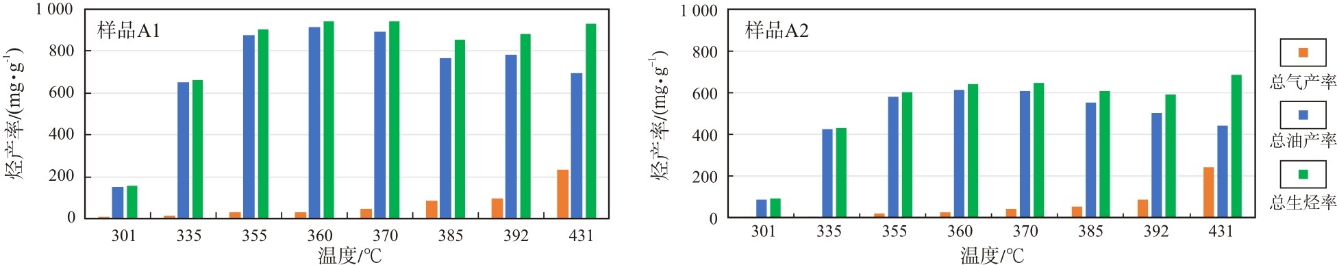
The shale of the Nenjiang Formation in the Songliao Basin generally exhibits a high total organic carbon content(TOC), locally exceeding 10%. However, the shale is mainly at low-to-medium maturity stage, making it a potential target stratum for in-situ conversion development. Although it is generally believed that higher TOC indicates greater hydrocarbon generation potential, there is still a lack of sufficient understanding regarding whether the in-situ conversion characteristics of different intervals depend solely on their TOC. Optimizing the most economical development intervals under a high TOC background requires additional selection criteria. In this study, two typical Nenjiang Formation shale samples with different organic abundance (with TOC of 9.63% and 5.08% respectively) are selected. Hydrocarbon generation kinetic parameters are obtained through thermal simulation experiments. By coupling the temperature field, an electric-heating in-situ conversion model is established to evaluate the in-situ development potential of the two typical Nenjiang Formation shales with varying abundances. The results indicate that both shale samples from the Nenjiang Formation predominantly generate oil. The high organic abundance shale yields more oil, whereas the low organic abundance shale has a slightly higher gas-oil ratio (GOR). With increasing heating time, the equivalent vitrinite reflectance (Easy Ro%) gradually increases from the heating well center to the periphery. By the third year, the Easy Ro% in the area within a 13 m radius from the heating well had exceeded 1.2%, indicating that the thermal maturation of organic matter in the main hydrocarbon generation zone is essentially completed. Under in-situ conversion conditions, both shales begin to generate significant amounts of oil after approximately two years of heating, reaching over 80% of their peak oil production rates in the third year. Furthermore, the cumulative oil production of the high organic abundance shale is about twice that of the low organic abundance shale. Given its higher cumulative oil production, the high organic abundance shale demonstrates superior in-situ development potential. These findings provide important theoretical support and exploration directions for the in-situ development of low-to-medium maturity shales of the Nenjiang Formation in the Songliao Basin.
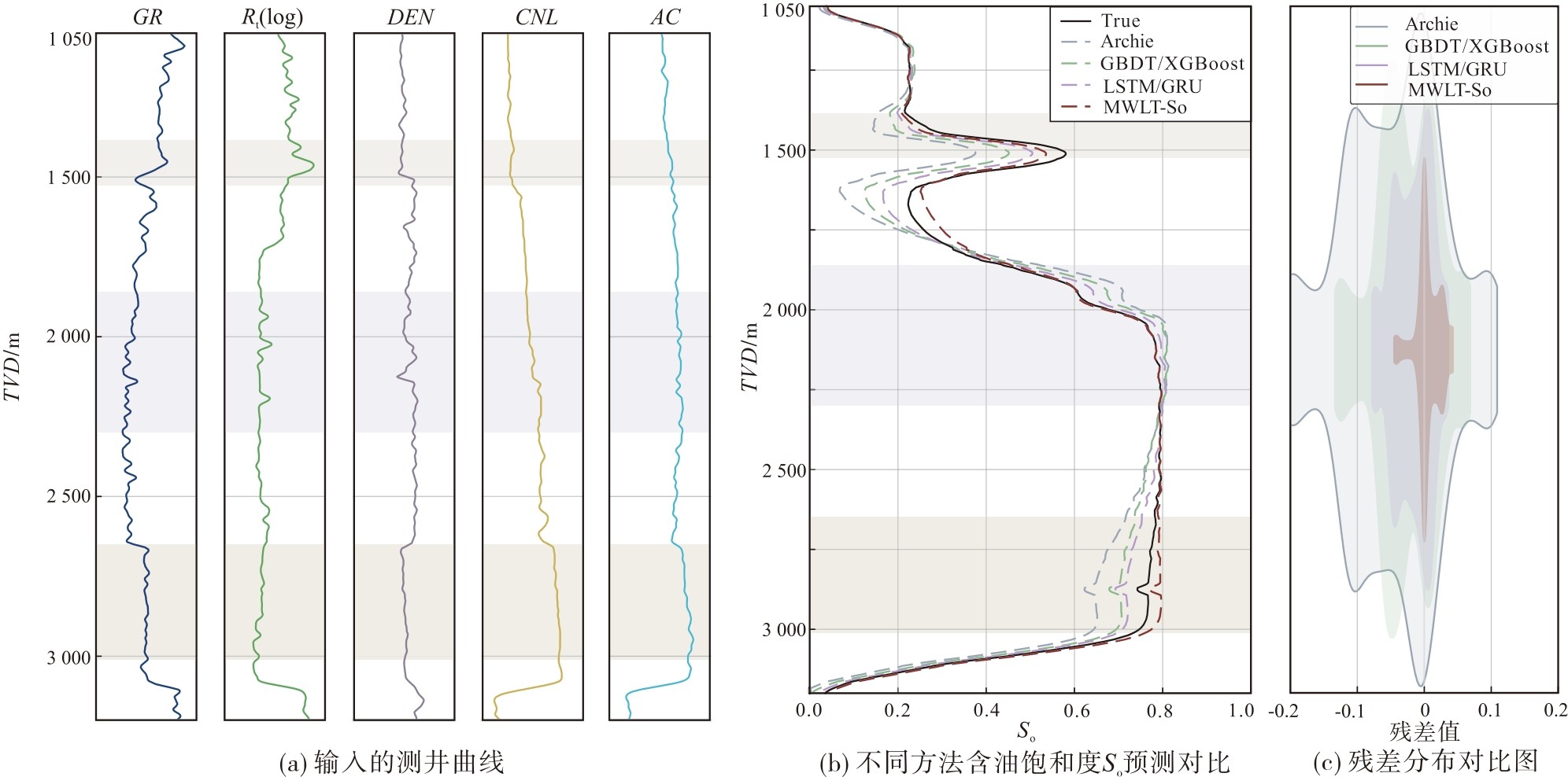
Accurate interpretation of oil saturation (So) traditionally relies on core analysis and empirical formulas, yet this process is challenged by scarce labeled samples, missing logging curves, and significant noise in logging data. To address these issues, this paper proposes a masked self-supervised Transformer-based method for oil saturation prediction from well logs, termed MWLT-So. First, multiple conventional logging curves are thoroughly aligned and standardized, and a random masking reconstruction task is designed to enable self-supervised pretraining on a large amount of unlabeled well interval, thereby learning generalizable representations with cross-well transferability. The pretrained model is then fine-tuned on a limited number of labeled samples using a regression objective, while multi-scale positional encoding and feature fusion are incorporated to enhance long-range dependency modeling. Comparative experiments across different blocks and various logging-curve combinations demonstrate that:(1) Under both random data split and rigorous well-wise split evaluation settings, MWLT-So achieves the best performance on the primary regression task. (2) MWLT-So shows clear advantages in terms of geological profile consistency and error distribution, accurately capturing boundary transition zones and high-So plateau intervals, while effectively overcoming common deficiencies of traditional methods such as over-smoothing, overshooting, and phase lag. Its residuals are more concentrated with thinner tails, and both the median error and dispersion are lower, indicating superior accuracy and robustness. (3) In the oil-bearing/non-oil-bearing identification task based on the threshold So = 0.5, MWLT-So attains the best classification performance with the lowest false-positive and false-negative rates, confirming its capability to reduce misclassification risk in threshold-based stratification scenarios. Overall, the proposed method provides effective technical support for rapid evaluation of complex reservoirs and identification of remaining oil.
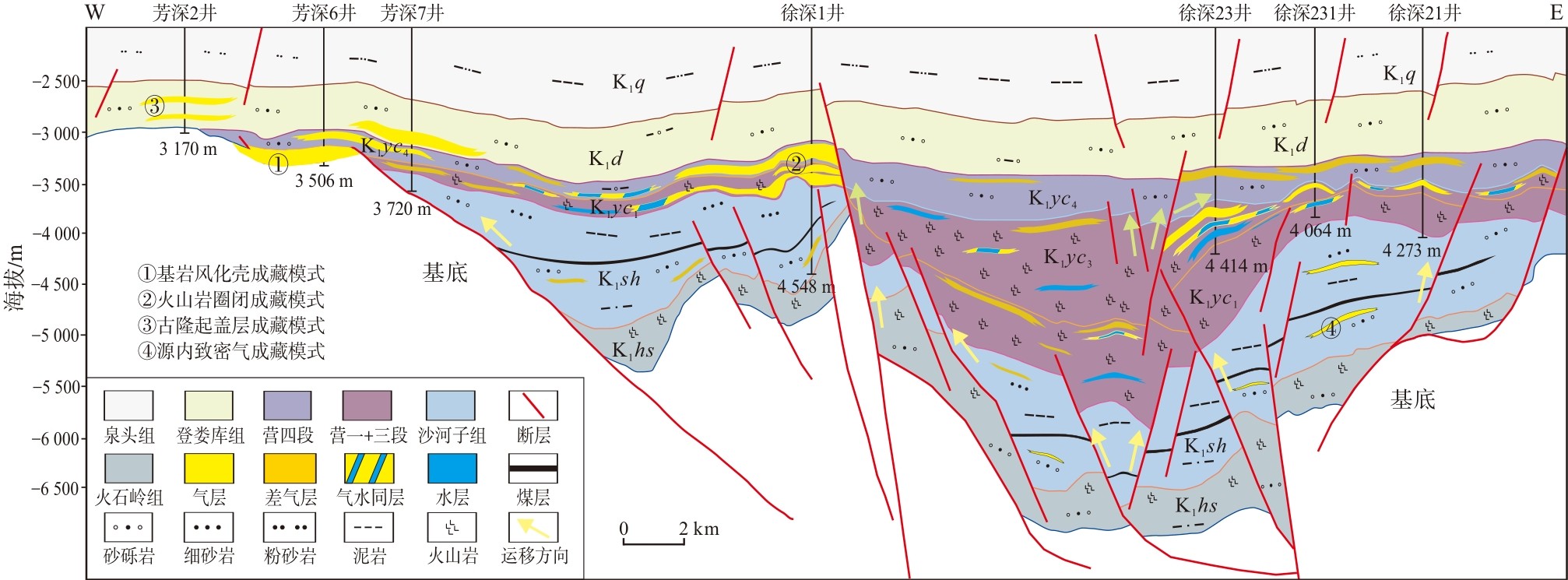
In recent years, with the continuous emergence of new theories, understandings, and achievements in exploration, the results of the "13th Five-Year Plan" resource evaluation have shown an unsuitability to the current needs of exploration work, and a new round of resource evaluation is urgently needed to provide a basis for accelerating natural gas exploration and development in the Songliao Basin. By analyzing the geological conditions of natural gas in the northern Songliao Basin, focusing on four main source rocks of the Nenjiang Formation, Qingshankou Formation, Yingcheng Formation, and Shahezi Formation, and targeting four sets of oil and gas combinations in the upper, middle, lower, and deep parts, four reservoir formation models are established, including bedrock weathering crust gas reservoir, volcanic rock gas reservoir, paleouplift cap rock gas reservoir, and intra-source tight gas. Two major categories and five types of analog calibration areas are selected, and natural gas resource evaluation is mainly carried out using the analogy method. The estimated in-situ natural gas resources in the Songliao Basin are 27 002×108 m3, including 17 100×108 m3 of conventional gas and 9 902×108 m3 of tight gas. Based on the distribution of remaining resources and combined with the analysis of geological conditions for natural gas accumulation and enrichment, the next exploration direction has been further clarified. It is believed that the tight gas of the Shahezi Formation in the Xujiaweizi Fault Depression, the volcanic gas of the Yingcheng Formation in the Yingshan-Gulong Fault Depression, and the buried-hill gas of the bedrock in the Central Paleo-uplift Belt are the realistic areas for increasing reserves in the near future.
The Erlian Basin is mainly focused on oil exploration, with a relatively low degree of natural gas exploration. Natural gas has been discovered in the Permian, Jurassic and Cretaceous strata. Based on geochemical analysis of the gas components and carbon isotopic compositions, the natural gas in the Erlian Basin can be classified into four genetic types: biogenic gas, oil-type gas, coal-type gas, and non-hydrocarbon gas. Gas maturity assessments and gas-source correlations reveal that the basin hosts multiple sets of gas-prone source rocks, including immature to low-mature coal and dark mudstone in the shallow Saihantala Formation of the Cretaceous, mature to high-mature dark mudstone in the middle-deep Arshan Formation of the Cretaceous, low-mature to high-mature coal-measure source rocks of the Jurassic, and mature to over-mature dark mudstone of the Carboniferous-Permian. The coal seams are thin but widely distributed, while the dark mudstones are nearly 1 000 m thick and extensively developed in the basin, with organic matter types of II2-III, providing a source rock foundation for natural gas generation. Natural gas accumulates in near-source structural highs, and there are five main favorable reservoir-seal assemblages, based on which accumulation models for shallow biogenic gas, mid-deep oil and gas, and deep natural gas are established. Using the genetic method and analogy method, the natural gas resources are evaluated. The calculated in-place resources are 2 411×108 m3 for the Carboniferous-Permian, 2 311×108 m3 for the Jurassic, 707×108 m3 for the Cretaceous Arshan Formation in four sags, and 1 425×108 m3 for the Cretaceous Saihantala Formation and Teng-2 member. Overall, favorable exploration targets include the near-source structural highs of the mature Arshan Formation in the sags, and the shallow biogenic gas traps of the Cretaceous Saihantala Formation and Teng-2 member. The Carboniferous-Permian in the eastern sags, and the Jurassic in inherited sags such as Honghaorshute, Aqituwula, and Gaolihan, have good exploration prospects.

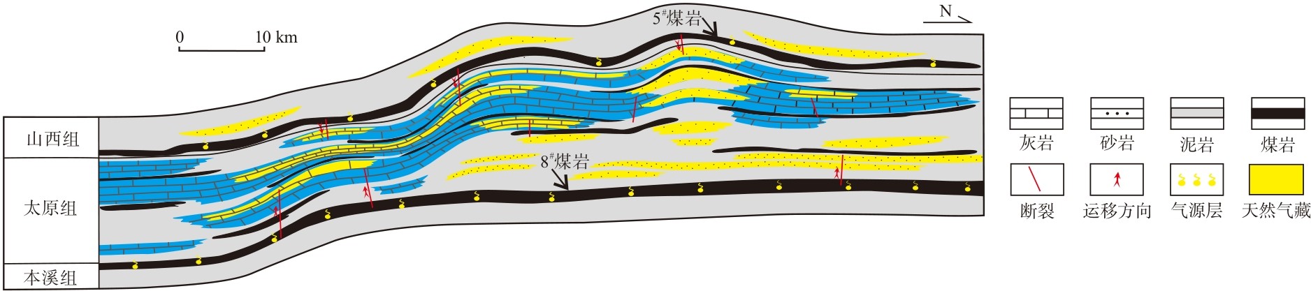
The exploration breakthrough of the Hengshan Gasfield in the Permian Taiyuan Formation limestone, regarded as a non-effective reservoir in a long term, has demonstrated its significant accumulation potential in the central-eastern Ordos Basin. This study systematically analyzes the geological conditions controlling natural gas accumulation and reveals a "sandwich-type" accumulation model, in which the coal seams of No. 5 in the Shanxi Formation and No. 8 in the Benxi Formation respectively served as source rocks, directly contact the limestone reservoir, and a high source-reservoir pressure difference about 8-12 MPa drives efficient gas charging. Bioclastic shoals (porosity of 2.6%, and thickness of 4-10 m) and bioherms (thickness of 2-6 m, dissolution pores developed) are identified as high-quality reservoirs, with fractures and penecontemporaneous karstification jointly improving reservoir performance. By integrating the volumetric method, small-element volumetric method, resource abundance analogy, and basin modeling, the total in-place natural gas resources of the Taiyuan Formation limestone are estimated at 1.553 5×10¹² m3, with the remaining unproven resources amounting to 1.544 7×10¹² m3. The bioclastic shoal facies has the highest enrichment (about 53.1% of the remaining unproven resources), being the priority exploration target. This study provides a critical basis for increasing natural gas reserves and production in the Ordos Basin and for evaluating similar tight carbonate gas reservoirs.


 Online Submission
 Peer Review
 Office Work
 Editor-in-Chief